|
|
|
|
|
|
| April 20, 2024 |
|
Record minimum for Arctic sea ice 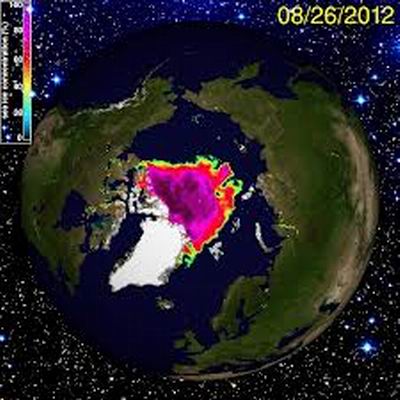
Arctic sea ice has reached its minimum extent for the year, setting a record for the lowest summer cover since satellite data collection began.
The 2012 extent has fallen to1.32 million sq miles - 50% lower than the 1979-2000 average. Arctic sea ice has long been regarded as a sensitive indicator of changes in the climate. Scientists who have been analyzing the startling melt think it is part of a fundamental change. "We are now in uncharted territory," said Mark Serreze, director of the National Snow and Ice Center (NSIDC) in Colorado. "While we've long known that as the planet warms up, changes would be seen first and be most pronounced in the Arctic, few of us were prepared for how rapidly the changes would actually occur." This year's minimum caps a summer of low ice extents in the Arctic. On September 4th, it fell below 1.54 million sq miles, a first in the 33-year satellite record. "We know very little about the consequences of drastic sea ice reductions. Most model predictions have sea ice declining less fast, said Dr Poul Christoffersen University of Cambridge. "The strong late season decline is indicative of how thin the ice cover is," said NSIDC scientist Walt Meier. "Ice has to be quite thin to continue melting away as the sun goes down and Fall approaches." Scientists say they are observing fundamental changes in sea ice cover. The Arctic used to be dominated by multiyear ice, or ice that survived through several years. Recently, the region is characterized by seasonal ice cover and large areas are now prone to completely melt away in summer. The sea ice extent is defined as the total area covered by at least 15% of ice, and varies from year to year because of changeable weather. However, ice extent has shown a dramatic overall decline over the past 30 years. (Source: BBC) Story Date: September 24, 2012
|
      |