|
|
|
|
|
|
| April 25, 2024 |
|
Storms assault Southland mountains, deserts 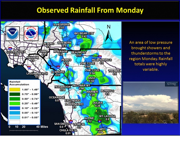
SOUTHLAND (INT) For the fourth day in a row, showers and isolated thunderstorms were in a hit-and-run mode across Southern California Monday.
Mountains, again, got the brunt of the action. Mud flows were seen rushing downhill near Wrightwood. In the valleys, thunder and lightning got some attention while hail clattered down on Murrieta. On the High Desert, a flash flood warning capped off the afternoon. Rain spread north from the Victor Valley and became intense north of Barstow as flash flood rushed across Ft. Irwin Road. Victorville picked up more than one-third--of-an-inch of rain in an hour. The last in a series of Pacific weather systems is moving inland before sunshine touches off a warming trend. The on-and-off showers are likely to boost Aprils cumulative total up to normal. As the core of the storm follows along the Southern California-Baja border, the heaviest showers have dampened the southern fringes of the Inland Empire. But since the rain arrived last Friday, 2-3 inches have been measured in the San Bernardino Mountains. Snow has fallen on the highest peaks. Its too late for skiers as the local resorts have closed for the season. Southland weather through Tuesday could be described as unsettled. But, calming high pressure takes over after mid-week returning temperatures to the 80s for the weekend. Rainfall from 4/8 to 9pm on 4/11/16 Riverside .54 Ontario .17 Moreno Valley 1.09 Hemet .29 Perris .53 Beaumont 1.14 Running Springs 3.58 Yucaipa Ridge 3.15 Palm Springs .11 Story Date: April 13, 2016
|
      |