|
|
|
|
|
|
| April 25, 2024 |
|
Satellites confirm some Bay Area spots sinking or moving 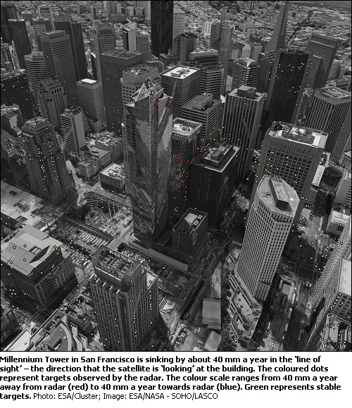
SAN FRANCISCO--New satellite data released by the European Space Agency confirms that San Franciscos 58-story Millennium Tower is sinking.
"The Sentinel-1 satellites have shown that the Millennium Tower skyscraper in the center of San Francisco is sinking by a few centimeters a year," a study by ESA says. "Studying the city is helping scientists to improve the monitoring of urban ground movements, particularly for subsidence hot spots in Europe." The swanky mirrored skyscraper at 301 Mission Street home to multi-million dollar apartments, some of them owned by celebrities like Joe Montana and Hunter Pence has been infamously nicknamed the "leaning tower of San Francisco," after it was revealed that the tower was tilting and sinking. The tower has sunk 16 inches into soft landfill in San Franciscos Financial District, and shifted two inches to the northwest since it was built nine years ago. According to ESA, this particular technique can also show displacement hot spots over large areas. ESA collaborated with Norut, PPO.labs and the Geological Survey of Norway to map other areas in the wider San Francisco that are moving: this includes buildings along the Hayward Fault as well gradual sinking of the newly reclaimed land in the San Rafael Bay. According to ESA, an uplift of the land was detected around the city of Pleasanton, possibly from the replenishment of groundwater following a four-year drought that ended in 2015. ESA did not immediately return a request for comment. The San Francisco City Attorneys office sued the buildings developers, Millennium Partners, earlier this month for failing to disclose that the building was sinking to buyers as early as 2009. California law mandates owners or developers to notify buyers of any problems or building defects and can be prosecuted under civil law for withholding the information. Although the exact cause of the tower tilting and shifting has not been pinpointed, it is believed to be connected to the buildings supporting piles not firmly resting on bedrock. In order to probe these subtle shifts, scientists combined multiple radar scans from the Copernicus Sentinel-1 twin satellites of the same area to detect subtle surface changes ESA scientists said in a statement the study is helping them to better monitor ground movements in cities, especially hot spots in Europe that are slowly sinking. The ESA study highlighted the area around a train station in Oslo, Norway, which is built on reclaimed land. Buildings around the station are built on bedrock, but the stations older parts are experiencing severe sinking. The Copernicus Sentinel-1 mission is, for the first time, making it possible to launch operational national deformation mapping services, said Dag Anders Moldestad from the Norwegian Space Center. (Source: NBC San Diego) Story Date: December 6, 2016
|
      |