|
|
|
|
|
|
| April 24, 2024 |
|
Soil burn in Apple Fire poses erosion and debris flow dangers 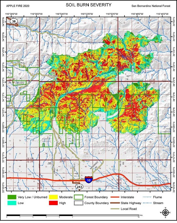
BANNING (INT) Fire recovery specialists have finalized a Soil Burn Severity map in the wake of the Apple Fire.
It ranges from low soil burn severity (20%), to moderate (50%) and high soil burn severity of 25%. The assessment team uses soil burn severity data to identify areas of concern where increased soil erosion, accelerated surface water run-off, and debris flows have the potential to impact human life/safety, property, and critical natural and cultural resources from future storm events. Erosion and run-off within the Apple Fire area is expected to increase because 75% of the burned area experienced moderate or high soil burn severity, team Leader Todd Ellsworth said. In specific areas that experienced moderate to high soil burn severity, there is concern for increased post-fire run-off from steep hillslopes and resultant increases in post-fire soil erosion and debris flows. The Apple Fire soil burn severity BAER map can be downloaded at the interagency Apple Post-Fire BAER InciWeb site (https://inciweb.nwcg.gov/incident/6939) as a JPEG or PDF version under the maps tab. Story Date: September 21, 2020
|
      |